


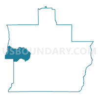
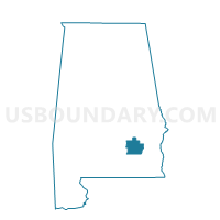
Rural Home- County Bldg, Pike County, Alabama
About
Outline

Summary
| Unique Area Identifier | 522825 |
| Name | Rural Home- County Bldg |
| County | Pike County |
| State | Alabama |
| Area (square miles) | 34.21 |
| Land Area (square miles) | 34.18 |
| Water Area (square miles) | 0.03 |
| % of Land Area | 99.92 |
| % of Water Area | 0.08 |
| Latitude of the Internal Point | 31.81451390 |
| Longtitude of the Internal Point | -86.12169330 |
Maps

Graphs
Select a template below for downloading or customizing gragh for Rural Home- County Bldg, Pike County, Alabama


Neighbors
Neighoring Voting District (by Name) Neighboring Voting District on the Map
- First Baptist Church- Troy, Pike County, AL
- Goshen Town Hall, Pike County, AL
- Patsburg Depot Building, Crenshaw County, AL
- Petrey Community Center, Crenshaw County, AL
- Shellhorn School, Pike County, AL
- Vidette Community Center, Crenshaw County, AL
Top 10 Neighboring County Subdivision (by Population) Neighboring County Subdivision on the Map
- Troy CCD, Pike County, AL (20,070)
- Luverne CCD, Crenshaw County, AL (6,989)
- Petrey-Highland Home CCD, Crenshaw County, AL (3,828)
- Goshen-Shady Grove CCD, Pike County, AL (2,431)
Top 10 Neighboring Unified School District (by Population) Neighboring Unified School District on the Map
Top 10 Neighboring State Legislative District Lower Chamber (by Population) Neighboring State Legislative District Lower Chamber on the Map
Top 10 Neighboring State Legislative District Upper Chamber (by Population) Neighboring State Legislative District Upper Chamber on the Map
Top 10 Neighboring 111th Congressional District (by Population) Neighboring 111th Congressional District on the Map
Top 10 Neighboring Census Tract (by Population) Neighboring Census Tract on the Map
- Census Tract 1890, Pike County, AL (8,053)
- Census Tract 9637, Crenshaw County, AL (3,809)
- Census Tract 1888, Pike County, AL (2,431)
- Census Tract 9634, Crenshaw County, AL (1,925)